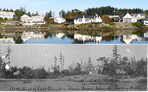
Join Boyd Pratt, Doug McCutchen and Mike Vouri for an evening of viewing 1890s images of the San Juan Islands by the U.S. Coast Survey’s John Gilbert, scheduled from 5:30 to 7 p.m., Thursday, Oct. 9 in the Orcas Island Library. The program is free. Vouri will open the discussion with a look at the first survey of the islands by the Coast Survey’s naval assistant, Lt. Cmdr. James Alden, and surveyor and map maker George Davidson operating from the U.S. Coast Steamer Active from 1853-1860. Pratt will follow with insights on Gilbert’s land-use T-sheets. McCutchen will then present a series of slides that capture from the same perspective today the sites of Gilbert’s images.
As an Assistant (a formal title), Gilbert accomplished most of his San Juan Islands survey in the Fuca, a 45-foot (12 feet abeam with a 5.5-foot draft) steam launch built by J.F.P. Mitchel in 1882. The Fuca was in service from 1882 to 1904 on the Pacific Coast and served Gilbert well in the Strait of Georgia surveys for most of that period. The hydrographic survey, meanwhile, was being done by Lt. J.N. Jordan with the schooner Earnest.
Gilbert’s topographic maps (known as “T-sheets”) of the San Juans reveal not only details of coastlines and land, but are also accompanied by lucid narratives and photographic images that capture the islands and surrounding regions before 20th Century development.
The “T-sheets” were largely forgotten documents until reintroduced on websites of Washington State University and University of Washington.