by TINA WHITMAN
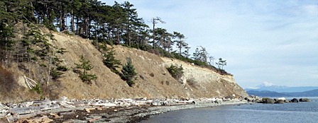
Have you ever wondered how popular sandy beaches such as Crescent Beach on Orcas, Jackson’s Beach on San Juan, South Beach on Shaw, or Odlin on Lopez came to exist amidst the many miles of rocky shoreline here? Geologists explain that beaches are linked by a trail of gravel and sand back to “feeder bluffs” – a term coined in the 1970s by local engineer Wolf Bauer to describe the role that bluffs play in providing the materials that create and sustain beaches.
Because feeder bluffs play such a crucial role in shaping our local shorelines, Friends of the San Juans and the Marine Resources Committee collaborated with Coastal Geologic Services of Bellingham to map current and pre-development feeder bluffs and beaches in San Juan County. Coastal Geologic Services has completed similar mapping projects in other Puget Sound counties, including Whatcom, King, Island, and parts of four other counties.
“By comparing current and historic conditions, you get a more accurate measure of the impacts to sediment supply- for example, 200 feet of armoring can have a much greater impact in an area with only 300 feet of historic feeder bluff, compared to an area with 3,000 feet of bluff,” notes researcher Andrea MacLennan of Coastal Geologic Services.
In addition to mapping the feeder bluffs through extensive field work, the survey looked at the quality of the feeder bluffs. Surveys found that a considerable portion of bluffs were armored with bulkheads, severely limiting the ability of the feeder bluff to provide beaches with essential gravel and sand. Friends and Coastal Geologic Services will explore opportunities to restore these bluffs and beaches.
The project also identified San Juan County’s remaining high quality feeder bluff areas that warrant protection, including Point Hammond on Waldron, Indian Cove on Shaw and Ship Bay on Orcas.
Countywide, 22 miles of feeder bluffs were mapped, representing current conditions. Historical analysis found that an additional five miles of feeder bluffs have been lost to development impacts such as residential bulkheads, docks, roads, and marinas. Lopez has the most feeder bluffs, with 33% of the San Juan County total. Orcas (16%), San Juan (15%), Decatur (10%), Waldron (9%), and Blakely (7%), are the other islands with more than five percent of the county’s total shoreline miles of feeder bluffs. Feeder bluff processes have been impacted by development most on Shaw, Orcas and Lopez Islands, respectively – as well as several of the non-ferry serviced islands including Pearl, Brown and Center Islands.
According to Friends’ Science Director, Tina Whitman, “Mapping for our county is now complete. Project results can be used by decision makers to help protect property and preserve spawning beaches for surf smelt and sand lance – the small fish that rely on local beaches for incubating their eggs and are an important food source for salmon, rockfish and seabirds.”
This week project reports and maps are being provided to coastal researchers, planners and managers to inform the local Shoreline Master Program update and salmon recovery efforts. Feeder bluff maps and reports are also available to any member of the public upon request.
Funding for the San Juan County Feeder Bluff Mapping Project was provided by the Puget Sound Partnership, the Northwest Straits Foundation and the Washington State Salmon Recovery Funding Board. For more information on Friends projects please visit our Web site at http://www.sanjuans.org.
Tina Whitman works for Friends of the San Juans.
Erosion happens – and your favorite local beach is the beneficiary | Guest Column
Array